TITLE: Observations of the Development and Vertical Structure of the Lake Breeze Circulation During the 2017 Lake Michigan Ozone Study
AUTHORS: Timothy J. Wagner, Alan C. Czarnetzki, Megan Christiansen, R. Bradley Pierce, Charles O. Stanier, Angela F. Dickens, and Edwin W. Eloranta
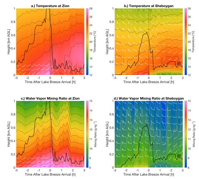
Time-height cross sections of temperature (top row, in °C) and mixing ratio (bottom row, in g kg-1) for the microwave radiometer at Zion (left column) and the AERI at Sheboygan (right column). Winds observed by the sodar at Zion and the Doppler lidar at Sheboygan are overlaid on the respective plots. Winds are shown in kt using the standard convention; this unit was chosen over m s-1 so that wind speed magnitudes would be large enough to be displayed with wind barbs. The 10 m surface winds at Sheboygan are appended at the bottom of the plot, but are displaced to the 30 m height for easier viewing. Temperature (mixing ratio) contours are every 1 °C (0.5 g kg-1). The thick black line represents the mixing depth calculated from the thermodynamic profiles.
ABSTRACT: Ground-based thermodynamic and kinematic profilers were placed adjacent to the western shore of Lake Michigan at two sites as part of the 2017 Lake Michigan Ozone Study. The southern site near Zion, Illinois, hosted a microwave radiometer (MWR) and a sodar wind profiler, while the northern site in Sheboygan, Wisconsin, featured an Atmospheric Emitted Radiance Interferometer (AERI), a Doppler lidar, and a High Spectral Resolution Lidar (HSRL). Each site experienced several lake breeze events during the experiment. Composite time series and time/height cross sections were constructed relative to the lake breeze arrival time so that commonalities across events could be explored.
The composited surface observations indicate that the wind direction of the lake breeze was consistently southeasterly at both sites regardless of its direction before the arrival of the lake breeze front. Surface relative humidity increased with the arriving lake breeze, though this was due to cooler air temperatures as absolute moisture content stayed the same or decreased. The profiler observations show that the lake breeze penetrated deeper when the local environment was unstable and pre-existing flow was weak. The cold air associated with the lake breeze remained confined to the lowest 200 m of the troposphere even if the wind shift was observed at higher altitudes. The evolution of the lake breeze corresponded well to observed changes in baroclinicity and calculated changes in circulation. Collocated observations of aerosols showed increases in number and mass concentrations after the passage of the lake breeze front.